
UA.II.A.K1: General airspace:
ACS Area II — Airspace Classification and Operating Requirements Task A: Airspace Classification References: 14 CFR part 71; AC 107-2; AIM; FAA-H-8083-25; FAA-G-8082-22
Key Concepts
Categories and Types of Airspace
U.S. airspace is divided into regulatory and nonregulatory categories, further classified into controlled, uncontrolled, special use, and other airspace types. These distinctions are based on factors like aircraft traffic density, types of operations, safety requirements, and national or public interests[1].
- Controlled Airspace: Includes Class A, B, C, D, and E airspace, each with specific altitude and geographic parameters where air traffic control (ATC) services are provided[1][8].
- Uncontrolled Airspace: Known as Class G, where ATC does not provide separation services, and pilots must follow basic visual flight rules (VFR)[2][7].
- Special Use Airspace: Areas with unique restrictions or activities, such as prohibited, restricted, and military operations areas (MOAs)[2][3].
Controlled Airspace: Classes A, B, C, D, and E
Class A Airspace
Class A airspace extends from 18,000 feet mean sea level (MSL) up to flight level (FL) 600, including airspace over waters within 12 nautical miles off the coast of the contiguous states and Alaska[1][4][8]. Operations require adherence to instrument flight rules (IFR); VFR operations are not allowed[4][8].
Class B Airspace
Class B airspace extends from the surface to 10,000 feet MSL around the busiest airports, with configurations resembling an “upside-down wedding cake”[1][4][8]. ATC clearance is required for entry and operation, and VFR aircraft must remain “clear of clouds.” It is depicted on sectional charts and VFR Terminal Area Charts (TAC)[1][4][6].
Class C Airspace
Class C airspace surrounds airports with significant passenger or IFR operations. Boundaries and vertical limits accommodate all instrument procedures and surrounding traffic. Two-way radio communications with ATC must be established before entering and maintained while operating within Class C[1][8].
Class D Airspace
Class D airspace typically surrounds airports with an operational control tower[1][5][8]. Vertical limits are published on aeronautical charts. Entry requires two-way radio communication with the tower. If the tower is closed, the airspace may revert to Class E or G, depending on published procedures[5]. Depicted with blue segmented lines on charts, aircraft are limited to a maximum speed of 200 knots (230 mph) at or below 2,500 feet within 4 nautical miles of the primary airport, unless authorized[5].
Class E Airspace
Class E airspace is controlled but not designated as Class A, B, C, or D[2][8]. The base varies: generally starting at 1,200 feet AGL, but in some areas at the surface or 700 feet AGL; where not depicted, it begins at 14,500 feet MSL. Class E extends up to, but not including, 18,000 feet MSL, and all airspace above FL 600 is Class E[2][7].
Uncontrolled Airspace: Class G
Class G airspace includes all airspace not designated as Class A, B, C, D, or E, thus considered uncontrolled[2][7]. Pilots are responsible for their own traffic separation and must follow VFR visibility and cloud clearance minimums specified in 14 CFR §91.155. Class G usually extends from the surface up to the overlying Class E base[2][7].
Special Use and Other Airspace
Special use airspace is designated for activities that may be hazardous to nonparticipating aircraft or impose operational limitations[2][3][7]. These areas include prohibited, restricted, warning, MOAs, alert areas, and controlled firing areas, confining or segregating certain activities for safety or security reasons.
Decoder Sheet
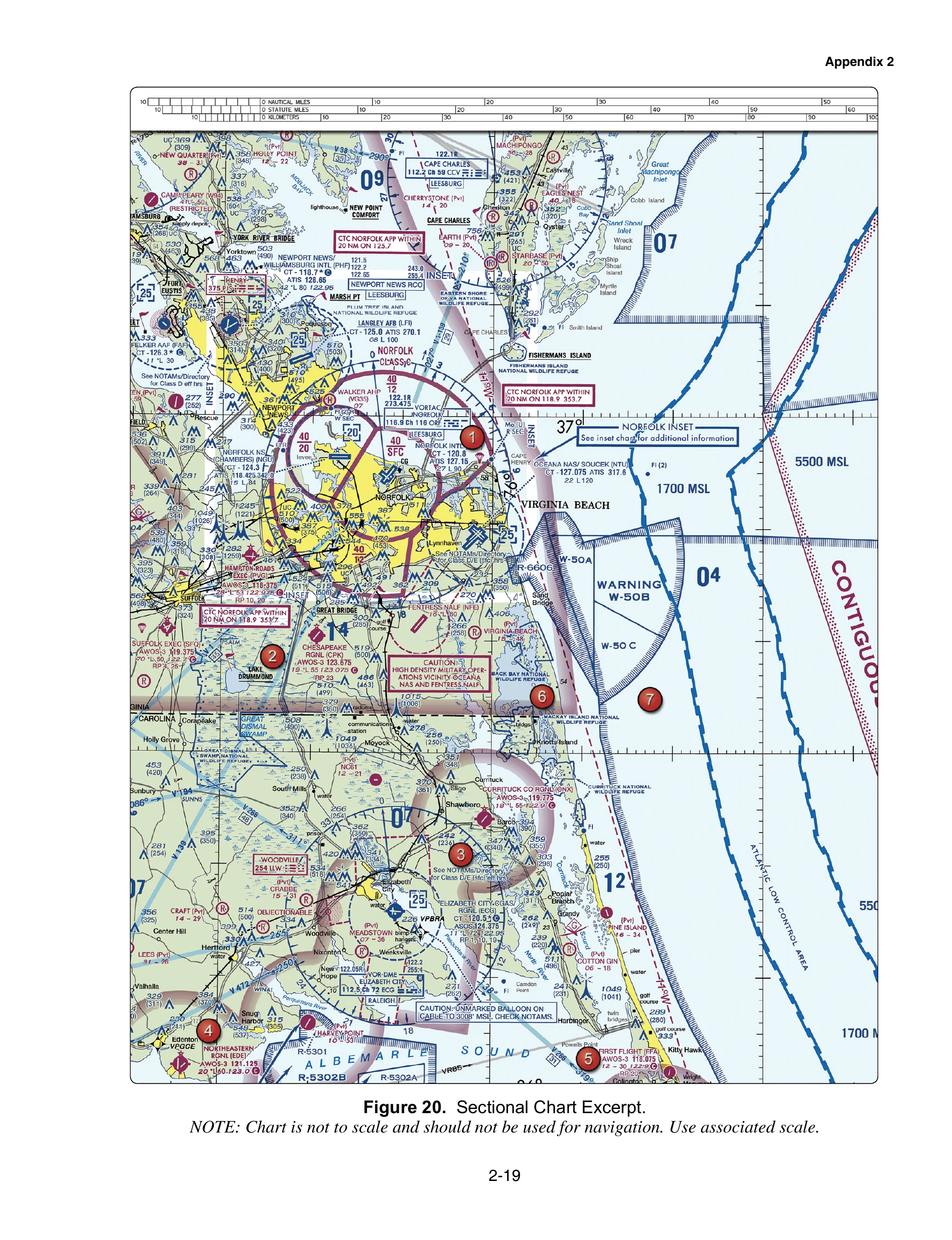
Norfolk, VA — Class B/C/D, Warning Areas, Restricted
Tap a marker, read the plain-English rule, then zoom into the same FAA-style chart without a second coordinate system.
FAA-CT-8080-2H (Public Domain) — Training only. Not for navigation or operational authorization.
Tap any symbol on the map · scroll to zoom
Figure 20 from FAA-CT-8080-2H: Norfolk, VA sectional. Click any highlighted circle to reveal the Part 107 rule for that symbol.
FAA-CT-8080-2H (Public Domain) — For training purposes only. Not for navigation.
FAA-CT-8080-2H Figure 20 — not to scale, not for navigation
Test Your Knowledge
Practice up to 10 questions specifically targeting UA.II.A.K1.