
UA.II.A.K2: Special-use airspace, such as prohibited, restricted, warning areas, military operation areas, alert
ACS Area II — Airspace Classification and Operating Requirements Task A: Airspace Classification References: 14 CFR part 71; AC 107-2; AIM; FAA-H-8083-25; FAA-G-8082-22
Key Concepts
Categories and Types of Special Use Airspace
Special Use Airspace (SUA) is airspace wherein activities must be confined due to their nature or limitations are imposed upon aircraft operations that are not part of those activities. SUA falls broadly into two groups: regulatory (prohibited and restricted areas) and nonregulatory (Military Operations Areas (MOAs), warning areas, alert areas, and controlled firing areas)[1][5][7]. Understanding the distinctions and operational implications of each type of SUA is essential for remote pilots, as entry requirements and associated risks differ.
Prohibited and Restricted Areas
Prohibited Areas: These are specifically defined airspace where all aircraft flight is strictly forbidden for reasons of national security or other critical national interests. A well-known example is the airspace over Camp David, designated as Prohibited Area P-40[3]. Drone pilots must never enter prohibited areas under any circumstances.
Restricted Areas: These areas contain airspace within which the flight of aircraft, while not wholly prohibited, is subject to restriction due to the existence of unusual, often invisible, hazards to aircraft, such as artillery firing, aerial gunnery, or missile activities. When a restricted area is active, access is only with controlling agency permission. Drone pilots must consult current aeronautical charts and NOTAMs to verify the status and controlling agency before considering entry[5][7].
Warning, Military Operation, and Alert Areas
Warning Areas: These extend from 3 nautical miles outward from the U.S. coast and contain activities that may be hazardous to nonparticipating aircraft. While not regulatory, entry into a warning area involves the same potential dangers as restricted areas, except that activities are over waters where the U.S. does not have full jurisdiction. Permission is not required, but extreme caution—along with awareness of ongoing hazardous operations—is necessary[7].
Military Operations Areas (MOAs): MOAs are established for the separation of certain military activities from IFR traffic. Operations such as air combat tactics, intercepts, and aerobatics may be ongoing. While MOAs do not exclude VFR (or drone) flights, remote pilots must exercise heightened see-and-avoid vigilance. The risks are significant: fast-moving, maneuvering military aircraft may be present who may not see a small UAS[7]. It is advisable to contact the controlling agency listed on the sectional chart for traffic advisories and the current status.
Alert Areas: These airspace segments may contain high volumes of pilot training or unusual aerial activity. All pilots in or transiting an alert area (including remote pilots) are equally responsible for collision avoidance. Unlike restricted or prohibited areas, there are no entry restrictions, but vigilance is critical[7].
Practical Considerations for Remote Pilots
- Chart Identification: All SUAs are depicted and identified on sectional and other aeronautical charts. Before each operation, remote pilots must review charts and NOTAMs for the presence and status of nearby SUAs[3][5].
- Procedural Compliance: Entry into prohibited areas is never permissible. Entry into an active restricted area requires advance permission from the controlling agency. MOAs, warning, and alert areas do not require explicit clearance, but presence of hazardous activity should always be verified, and heightened see-and-avoid measures must be taken[7].
- Notification and Coordination: For MOAs and restricted airspace, contact the controlling agency (frequency published on sectional charts) before flight to determine status and request advisories when practical.
- Operational Limits: Remote pilots must remember that activities within SUAs may not be visible from the ground or drone’s perspective; even when entry is legally allowed, prudent pre-flight planning and ongoing airspace awareness are critical to safety.
Decoder Sheet
Norfolk, VA — Class B/C/D, Warning Areas, Restricted
Tap a marker, read the plain-English rule, then zoom into the same FAA-style chart without a second coordinate system.
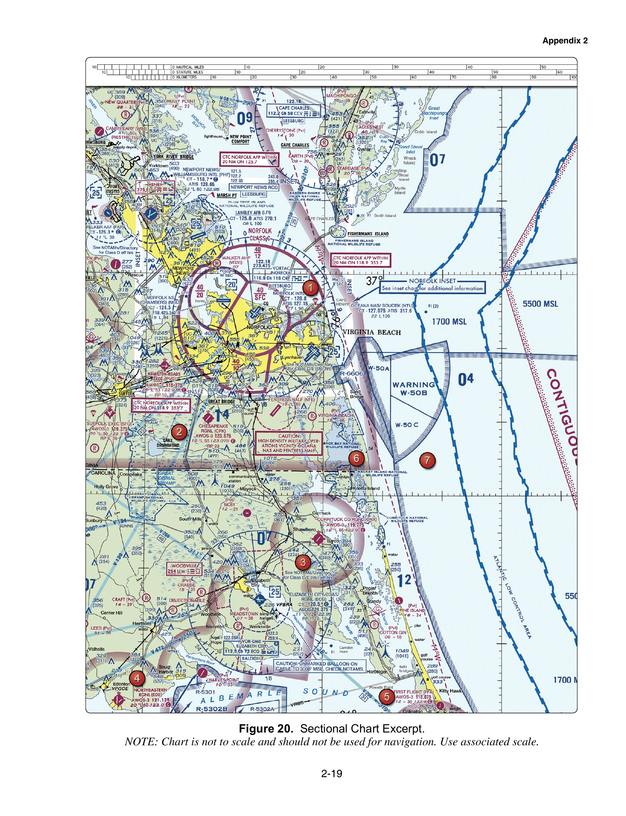
FAA-CT-8080-2H (Public Domain) — Training only. Not for navigation or operational authorization.
Tap any symbol on the map · scroll to zoom
Figure 21 from FAA-CT-8080-2H: Minot, ND sectional. Click any highlighted circle to reveal the Part 107 rule for that airspace type.
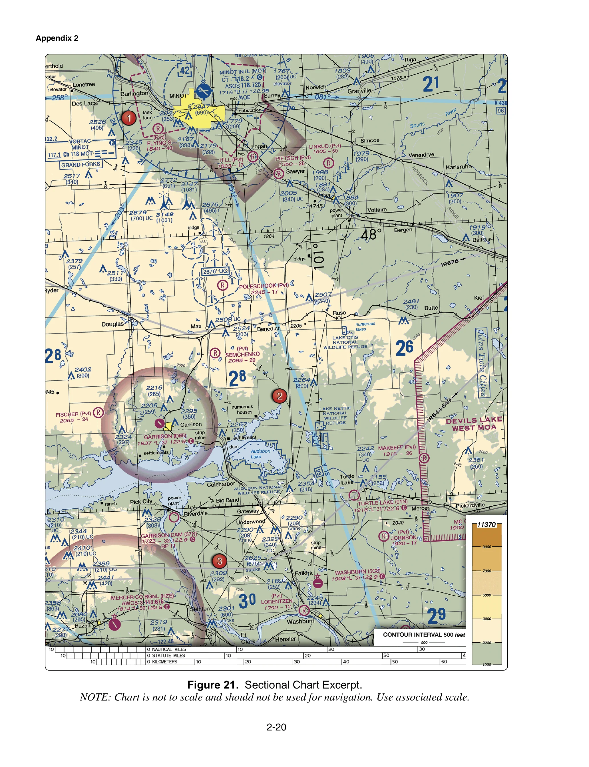
FAA-CT-8080-2H (Public Domain) — For training purposes only. Not for navigation.
FAA-CT-8080-2H Figure 21 — not to scale, not for navigation
Test Your Knowledge
Practice up to 10 questions specifically targeting UA.II.A.K2.