
Airport Traffic Patterns for Drone Pilots
Upwind, crosswind, downwind, base, final: how manned traffic flies around an airport, how runway numbers work, and how to place an aircraft from a radio call.
A drone pilot never flies the traffic pattern, but has to know where the airplanes in it are. 14 CFR §107.43 forbids operating in a way that interferes with operations and traffic patterns at any airport, and the test checks that you can turn a radio call like "midfield left downwind, runway 13" into a position on the map.
What are the legs of a traffic pattern?
The AIM names five legs:
| Leg | Direction |
|---|---|
| Upwind | Parallel to the runway in the landing direction, an extension of the departure |
| Crosswind | At right angles to the runway, off its takeoff end |
| Downwind | Parallel to the runway, opposite to the landing direction |
| Base | At right angles to the runway, off its approach end |
| Final | Along the extended centerline, toward the runway |
The AIM recommends that propeller airplanes fly the pattern at 1,000 feet AGL and large or turbine aircraft at 1,500 feet AGL or higher. Helicopters may fly a smaller pattern at 500 feet AGL. Minot's Chart Supplement entry, for example, lists a standard pattern altitude of 1,000 feet. On final, every one of them descends through drone altitudes.
1,000 ft AGL
the AIM's recommended pattern altitude for propeller airplanes
Left or right traffic?
Left is the default. At an airport without an operating tower in Class G airspace, 14 CFR §91.126 requires airplanes approaching to land to make all turns to the left, unless approved light signals or visual markings show right turns. The AIM says right patterns are shown on sectionals with "RP" and the runway numbers at the bottom of the airport data block. On FAA Figure 22, Coeur d'Alene shows "RP 2": right traffic for runway 2.
Airports may also show the pattern on the ground with a segmented circle. The AIM describes its traffic pattern indicators as showing the direction of turns when there is a variation from the normal left pattern.
How do runway numbers work?
The AIM says a runway number is its magnetic direction to the nearest 10 degrees, with the last zero dropped. A runway pointing 183° magnetic is runway 18, and one pointing 87° is runway 9. The other end of the same strip is 180° different: runway 13 is runway 31 seen from the other end. Parallel runways add L, C or R.
How do you place an aircraft from a radio call?
Take the FAA's sample question: an aircraft reports "midfield left downwind runway 13" at Cooperstown.
- Runway 13 points about 130°, so landings go toward the southeast.
- Downwind is flown the opposite way, about 310°.
- In a left pattern, the runway is on the pilot's left. Flying 310° with the runway on the left puts the aircraft on the northeast side of the runway.
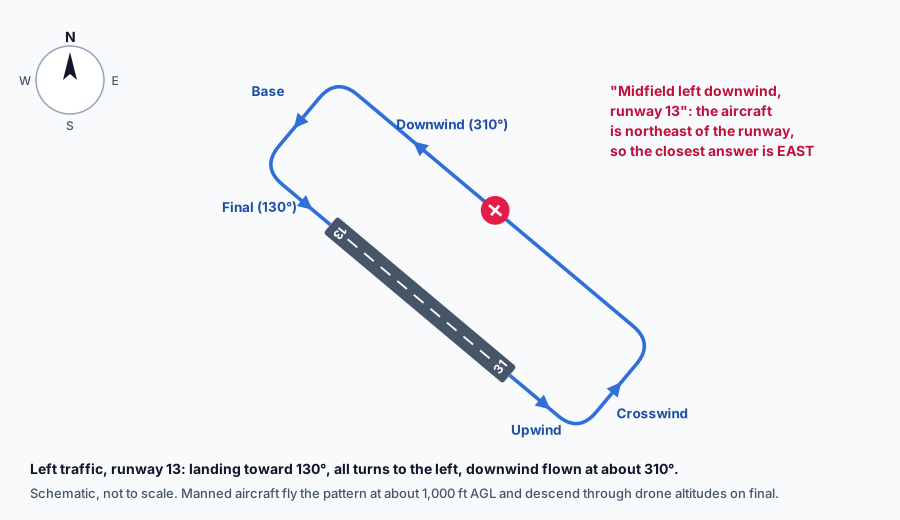 Left traffic pattern for runway 13 with an aircraft at midfield downwind, northeast of the runway
The answer choices are east, south and west, so east. A drone launch site east of that runway is under the downwind leg. The airport operations post covers the radio side, including CTAF self-announcements.
The pattern is only one reason to stay clear. At a towered airport you are likely in Class D airspace and need authorization anyway. At a non-towered airport in Class G, no authorization is required, but §107.43 still applies and you yield to every manned aircraft.
What the exam asks about traffic patterns
The ACS lists traffic patterns used by manned aircraft as UA.V.B.K4, and radio self-announcements under UA.V.A. Expect pattern-leg definitions, runway-number questions, and a position question like the one above. The sample questions post has the FAA's version.
Runway number, opposite heading, which side. Three steps place any aircraft in the pattern.
The beacons, runway lights and hold lines around that pattern are covered in the lights and markings post, and the radio calls in the phraseology post.
Whether you need authorization near a given airport is covered in the airport post.
Operations is a quarter of the test. The free diagnostic shows how you score there against the current blueprint.
Check your operations knowledgeFree diagnostic
Reading about drones is one thing. Passing the Part 107 test is another. See where you stand.
Take the free 10-minute diagnostic