
Class D Airspace for Drones: Towered Airports
Class D surrounds towered airports from the surface to about 2,500 feet above the field. How to read it on a sectional, and what changes when the tower closes.
Class D is the airspace around airports that have an operating control tower but not enough traffic for Class B or C. The AIM says it generally runs from the surface to 2,500 feet above the airport elevation, charted in MSL. Because it starts at the ground, any Part 107 flight inside it needs prior ATC authorization under 14 CFR §107.41.
How does Class D look on a sectional chart?
The FAA Chart User's Guide says Class D is identified with a dashed blue line, and its ceiling is printed in a dashed blue box in hundreds of feet MSL. A minus sign in front of the number means "from the surface up to, but not including" that altitude, which happens where Class D meets a Class C or B shelf above it.
The FAA's Figure 21 shows Minot International (MOT) in North Dakota with a ceiling box reading 42: Class D from the surface to 4,200 feet MSL. The airport elevation printed in the airport data is 1,716 feet, and 1,716 plus 2,500 is about 4,200, which is the AIM's rule of thumb in action.
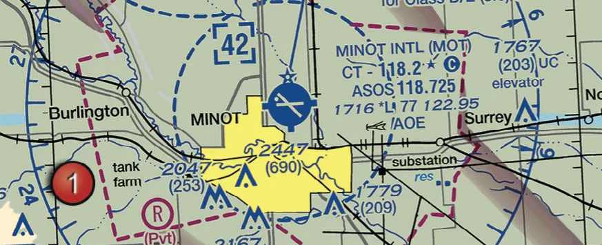 Minot International on FAA Figure 21: dashed blue Class D boundary with a ceiling box reading 42
2,500 ft
the usual height of Class D above the airport elevation, per the AIM
What happens when the tower closes?
Some towers are not open around the clock. The AIM says a part-time Class D surface area changes, outside tower hours, to either a Class E surface area or Class G airspace, and the Chart Supplement entry for the airport says which, for example "other times CLASS E" or "other times CLASS G".
That matters for a drone:
- Reverts to Class E surface area: you still need authorization, because §107.41 covers Class E surface areas too. The Class E post explains how those are drawn.
- Reverts to Class G: no ATC authorization is required while the tower is closed, but every other Part 107 rule still applies.
On the chart, a star next to the tower frequency marks a part-time tower. Minot's entry reads CT 118.2 with a star, which is your cue to check the Chart Supplement for hours.
Authorization is about the airspace, not the tower radio. You request it through LAANC or FAA DroneZone before the flight, and you do not need to call the tower afterward unless the authorization itself says so, as the LAANC post explains.
What the exam asks about Class D
The element is UA.II.A.K1, sub-element c. Expect a chart excerpt with a dashed blue line and a boxed number, and questions such as: what is the ceiling, is authorization needed at a marked point, or which frequency is the tower. The airport operations post covers frequencies and traffic patterns.
Dashed blue line, boxed ceiling, authorization from the surface up.
The airspace classes overview compares Class D with the larger Class C.
The hours themselves are in the Chart Supplement: Minot's entry reads "CLASS D svc 1300–0400Z‡; other times CLASS E." Where the manned traffic flies around a towered field is in the traffic pattern post.
Most facility map grids sit around Class D airports; the further coordination post explains how to request more altitude.
Practice reading boxed ceilings and tower frequencies on the same figure the test uses.
Find Minot's Class D on FAA Figure 21Free diagnostic
Airspace is the single densest topic on the test. See what you actually know.
Take the free 10-minute diagnostic