
Drone Airspace Classes: B, C, D, E and G
Which airspace classes need ATC authorization for a Part 107 drone, how each one looks on a sectional chart, and how to tell which one you are standing in.
For a Part 107 drone, airspace comes down to one rule. 14 CFR §107.41 says you need prior authorization from air traffic control to fly in Class B, Class C or Class D airspace, or within the lateral boundaries of a Class E surface area designated for an airport. Everywhere else in the lower airspace, which is Class G and the Class E that starts above you, needs no ATC authorization. The hard part is knowing which class is over your launch point.
Which airspace classes need authorization?
| Class | Typical shape (per the AIM) | Sectional chart symbol | Part 107 authorization? |
|---|---|---|---|
| Class B | Surface to 10,000 ft MSL, layered like an upside-down wedding cake | Solid blue lines, blue MSL altitudes | Yes |
| Class C | 5 NM core from the surface, 10 NM shelf from 1,200 ft, up to 4,000 ft above the airport | Solid magenta lines, magenta MSL altitudes | Yes |
| Class D | Surface to 2,500 ft above the airport | Dashed blue line, ceiling in a box | Yes |
| Class E surface area | From the surface around an airport without an operating tower | Dashed magenta line | Yes |
| Class E above you | Floors at 700 ft AGL, 1,200 ft AGL, or 14,500 ft MSL | Magenta or blue vignette, or nothing | No, at drone altitudes you are below it |
| Class G | Everything not designated as another class | No symbol of its own | No |
Class A starts at 18,000 feet MSL and is not depicted on VFR charts. It never comes up at drone altitudes.
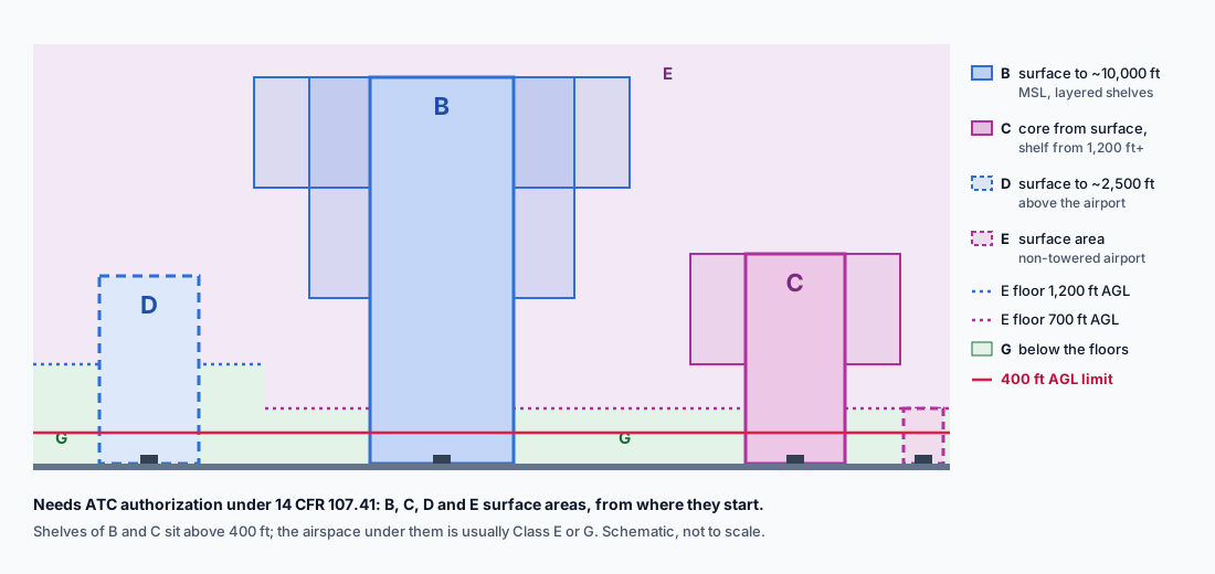 Schematic cross-section of Class B, C, D, E and G airspace with the 400-foot Part 107 limit
4 of 6
airspace types in the table above that need ATC authorization before a Part 107 flight
How do you tell which class you are in?
- Find your launch point on a current sectional or an app that draws the same boundaries.
- Look for a line that encloses you. Solid blue is Class B, solid magenta is Class C, dashed blue is Class D, and dashed magenta is a Class E surface area. Inside any of these, from the surface up, you need authorization.
- If you are under a shelf, read its floor. A Class B or C shelf that starts thousands of feet up is above a 400-foot drone, and what is below it is usually Class E or G. Check for a surface area underneath as well.
- If no line encloses you, look at the shading. A magenta vignette means Class E starts at 700 feet AGL, and a blue vignette means it starts at 1,200 feet. At 400 feet or below you are in Class G.
The sectional chart guide walks through these symbols on real FAA excerpts, and the sectional symbols cheat sheet covers the rest of the legend.
Class is not the only question. Prohibited and restricted areas, TFRs and stadium restrictions apply in every class, including Class G. The restricted airspace post covers those rules.
How do you get authorization?
In most controlled airspace around airports, through LAANC: an FAA-approved app checks your request against the UAS Facility Map for that grid and usually answers within minutes. Where LAANC is not available, or you need more than the facility map allows, you apply through FAA DroneZone. The LAANC post explains both request types.
What the exam asks about airspace
Airspace classification is ACS task UA.II.A, and the element UA.II.A.K1 splits into sub-elements a through e for Class B, C, D, E and G. Expect chart figures where you must name the class at a marked point, read a floor or ceiling in MSL, and decide whether authorization is needed. The FAA's own sample questions include three such questions on Class C alone.
Identify the class, then read the floor. Most airspace questions are decided by those two steps.
Temporary restrictions sit on top of every class; the drone TFR post explains how to find them.
For the most common version of the question, "how close to an airport can I fly?", see the airport post.
The free chart trainer uses the same FAA figures as the test, with every airspace boundary explained.
Practice on real FAA sectional figuresFree diagnostic
Airspace is the single densest topic on the test. See what you actually know.
Take the free 10-minute diagnostic