How to Read an Unfamiliar Sectional Chart
The Part 107 test now shows chart excerpts you have never seen. A five-step routine, worked through on the FAA's Millville and Grand Canyon sample questions.
Since October 26, 2026, the Part 107 test can show you a piece of a current sectional chart that is not in the testing supplement, as the test changes post explains. You cannot memorize your way through that. You need a routine that works on any chart. Here it is, applied to the two sample questions the FAA published in its September 2026 advisory.
A five-step routine for any chart excerpt
- Find the airport the question names and note its color. The FAA's Chart User's Guide prints towered airports and their data in blue, all others in magenta.
- Read the line around it. Solid blue is Class B, solid magenta Class C, dashed blue Class D, dashed magenta a Class E surface area. No line and no vignette at that spot usually means Class G at drone altitudes.
- Read the data block in order: elevation, lighting, longest runway in hundreds of feet, then frequencies. CT means control tower, a star after it means part-time, and a circled C marks the CTAF.
- Decide on authorization. Under §107.41, Class B, C and D, and the surface area of Class E designated for an airport, need ATC authorization.
- Eliminate answers that mix the symbols up, such as a tower on a magenta airport or Class B "under" Class D.
The sectional chart symbols post and reading airspace on a sectional cover each symbol in more depth.
Sample 1: Millville Municipal (MIV)
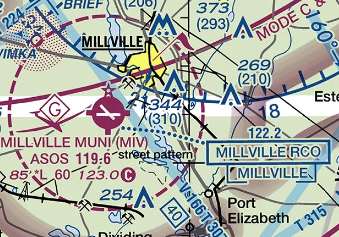 FAA sample sectional excerpt around Millville Municipal Airport (MIV) with a dashed magenta Class E surface areaImage: FAA Airman Testing Community Advisory, September 2026
The question: what type of airspace is associated with Millville Muni (MIV), and is ATC authorization required to operate a small UA there?
- Step 1. The airport name and symbol are magenta, so there is no control tower.
- Step 2. A dashed magenta circle surrounds the airport: a Class E surface area.
- Step 3. The data block reads
85 *L 60 123.0 C: elevation 85 feet, lighting with limitations, a 6,000-foot longest runway, and 123.0 as the CTAF. - Step 4. A Class E surface area designated for an airport needs authorization under §107.41.
So the answer is Class E associated with an airport surface area, authorization required, which is the FAA's keyed answer. The distractors fail step 1 or 2: one puts an operating control tower on a magenta airport, the other invents Class B under Class D. The Class E post explains why a dashed magenta line means authorization while a magenta vignette does not.
Sample 2: Grand Canyon National Park (GCN)
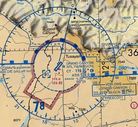 FAA sample sectional excerpt around Grand Canyon National Park Airport (GCN) showing CT 119.0 with a star and a circled CImage: FAA Airman Testing Community Advisory, September 2026
The question: if the GCN control tower is not in operation, which frequency should be used as the CTAF?
- Step 1. The airport is blue, so it has a control tower, and the dashed blue line around it is Class D.
- Step 3. The data block shows
CT - 119.0followed by a star and a circled C. The star means the tower is part-time. The circled C after 119.0 means that frequency is also the CTAF when the tower is closed. - The other frequencies in the answer choices are there to catch rushed readers: 124.3 is labeled ATIS, and 122.95 appears on the line below, not next to the circled C.
So the answer is 119.0, the FAA's keyed answer. The supplement's Figure 21 uses the same convention: Minot reads CT 118.2 with a star, as the sectional chart symbols post shows.
When a part-time tower closes, the Class D surface area becomes Class E or Class G, and the Chart Supplement entry for the airport says which, as the Class D post explains. The Chart Supplement post shows where to look.
How to practice for chart questions you cannot preview
- Download a current sectional from the FAA's VFR charts page, free, and run the five steps on airports you do not know.
- Say the answer out loud before reading the choices. It stops the distractors from steering you.
- Time yourself. Two minutes per question is the average budget on the real test, and chart questions use more of it, as the test day checklist explains.
Color, line, data block, authorization. Four looks answer most chart questions on any sectional.
The free chart trainer quizzes airspace and symbols with zoom and focus.
Drill the five steps on practice chartsFree diagnostic
Airspace is the single densest topic on the test. See what you actually know.
Take the free 10-minute diagnostic