
Sectional Chart Symbols for Part 107
A cheat sheet for the sectional chart symbols the Part 107 test uses: airport data blocks, obstacles, MEF numbers, special use airspace and military routes.
About a fifth of the Part 107 test is airspace, and much of it is read off FAA sectional chart excerpts. The legend is long, but the test leans on a small part of it. Everything below comes from the FAA's Aeronautical Chart User's Guide, the official key to every symbol, with examples from the FAA test figures.
How do you read an airport's data block?
The Chart User's Guide says airports with control towers and their data are printed in blue, and all other airports in magenta. The data block under the name follows a fixed order. Coeur d'Alene on Figure 22 reads:
2320 *L 74 122.8 C
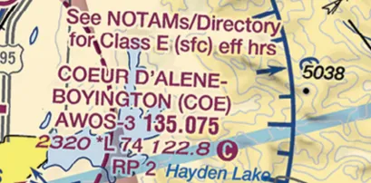 Coeur d'Alene airport data block on FAA Figure 22, with CTAF 122.8 marked by a circled C
| Item | Meaning |
|---|---|
| 2320 | Airport elevation in feet MSL |
| *L | Runway lights with limitations; check the Chart Supplement |
| 74 | Longest runway, in hundreds of feet: 7,400 ft |
| 122.8 | UNICOM frequency |
| C (circled) | The frequency it follows is the CTAF |
On a towered airport, the line starts with CT and the tower frequency. A star after it means the tower is part-time, and the hours are in the chart's tower tabulation and the Chart Supplement. Minot on Figure 21 reads "CT - 118.2" with a star.
2320
Coeur d'Alene's elevation in feet MSL, the first number in its data block
How are obstacles shown?
- Two tower symbols. One for obstacles under 1,000 feet AGL and a taller one for 1,000 feet AGL or more. The guide says sectionals generally show obstacles over 200 feet AGL, or over 299 feet AGL inside yellow city tint.
- Two numbers. The top of the obstacle in feet MSL, and below it in parentheses its height AGL. On Figure 21, an obstacle labeled 2447 (690) is 2,447 feet MSL and 690 feet above the ground.
- UC next to an obstacle means under construction or not yet verified.
- Group obstacles in dense areas show only the highest one, so a single symbol may stand for several towers.
- Wind turbine farms are drawn as a hatched area with a boxed MSL elevation of the highest turbine.
A tall tower is the classic exam setup for the rule that lets a drone fly higher than 400 feet within 400 feet of a structure. The 400 feet post covers how that works.
What is the big number in each grid square?
That is the Maximum Elevation Figure. The guide defines it as the highest elevation in a quadrant of 30 minutes of latitude by 30 minutes of longitude, terrain and obstacles included, rounded up to the next 100 feet with the last two digits dropped. A large 2 with a smaller 8 means 2,800 feet MSL.
The quadrants are bounded by the ticked latitude and longitude lines. Each tick is one minute, which is how the test's coordinate questions are answered: the FAA's sample question about 47°40'N, 101°26'W is solved by counting ticks from the 48° and 101° lines on Figure 21.
How is special use airspace drawn?
| Symbol | Airspace | What a drone pilot does |
|---|---|---|
| Blue hatched border | Prohibited (P), Restricted (R), Warning (W) | P and R: get permission from the using or controlling agency first, under §107.45 |
| Magenta hatched border | MOA and Alert areas | Check the times of use; expect fast military or training traffic |
| Broken magenta line | National Security Area | The guide says to avoid flying through it; flight may be temporarily prohibited |
| Broken blue line | TFR relating to national security | Only national security TFRs are charted; check NOTAMs for the rest |
| Gray line with IR or VR number | Military training route | Four-digit numbers mean no segment above 1,500 ft AGL |
The guide adds that the chart margin lists every prohibited, restricted, warning and alert area and MOA, with altitudes, times of use and the controlling agency. That table is the answer to the FAA sample question on how to find out whether a MOA is active.
Most TFRs are not on the chart. The guide says only TFRs relating to national security are charted. Sporting events, fires and VIP movements show up only in NOTAMs, so a chart alone is never a full preflight.
What else shows up on test figures?
- Caution boxes near hazards. Figure 20 has one for an unmarked balloon on a cable to 3,008 feet MSL.
- Wildlife refuges and national park outlines, where manned pilots are asked to stay high. For drones, the restricted airspace post covers the related rules.
- Class airspace lines, covered class by class in the airspace classes overview.
MSL on top, AGL in parentheses. Half the chart questions turn on that one convention.
What the exam asks about chart symbols
Chart reading sits mostly under UA.V.B.K6, sources for airport data, and the airspace elements in UA.II. The sectional chart guide works through the boundaries in more detail, and the FAA sample questions post shows how the FAA phrases chart questions.
Coordinate questions have their own method, covered in the latitude and longitude post, and the full airport directory behind each data block is the Chart Supplement.
What those tower symbols mean in the air, including guy wires that reach far from the mast, is in the flight hazards post.
To apply these symbols to a chart you have never seen, follow the routine in how to read an unfamiliar sectional chart.
Every hotspot in the chart trainer explains a symbol from the figures used on the real test.
Practice on the FAA test figuresFree diagnostic
Airspace is the single densest topic on the test. See what you actually know.
Take the free 10-minute diagnostic