Latitude and Longitude on a Sectional Chart
Coordinate questions on the Part 107 test are pure counting. How to read latitude and longitude on a sectional and convert decimals to minutes.
Several Part 107 questions give you coordinates and ask what is there, or point at a spot and ask for its coordinates. They look intimidating and are the most mechanical questions on the test: find two labeled lines, count tick marks, and check direction. The FAA's Pilot's Handbook of Aeronautical Knowledge defines longitude as the measurement east or west of the Prime Meridian, which is 0° and runs through Greenwich, England. Latitude is measured north or south of the equator.
How are coordinates written?
Each degree is divided into 60 minutes. A position such as 47°40'N, 101°26'W means 47 degrees 40 minutes north and 101 degrees 26 minutes west. In the United States, latitudes are always north and longitudes always west, so on a sectional:
- Latitude grows toward the top of the chart (north).
- Longitude grows toward the left of the chart (west). This is the trap: moving left increases the west longitude.
Sometimes the test writes coordinates as decimals, such as 46.9N and 98.6W. Multiply the decimal part by 60 to get minutes: 0.9° is 54 minutes and 0.6° is 36 minutes, so the point is 46°54'N, 98°36'W.
How do you find them on the chart?
Sectionals print a line of latitude and a line of longitude every 30 minutes, labeled with the degree at whole-degree lines. The FAA's Chart User's Guide calls the boxes between them quadrants and uses them for the Maximum Elevation Figures. Each line carries small tick marks, one per minute of the other coordinate.
- Find the nearest labeled lines. On FAA Figure 21 those are the 48° parallel and the 101° meridian.
- Count latitude ticks along a meridian from the labeled parallel: up for more north, down for less.
- Count longitude ticks along a parallel from the labeled meridian: left for more west, right for less.
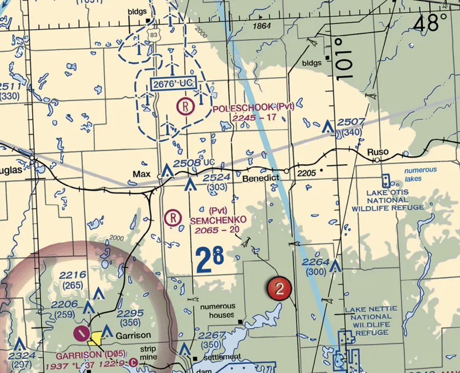 FAA Figure 21 excerpt showing the 48 degree parallel, the 101 degree meridian and Garrison airport to the southwest
1 minute
of latitude is about one nautical mile, which is why the latitude ticks line up with the chart's mileage scale
Worked example: the FAA's Garrison question
The FAA's sample question asks which airport is at about 47°40'N, 101°26'W on Figure 21. From the 48° line, 47°40' is 20 minutes south: count 20 ticks down. From the 101° meridian, 101°26' is 26 minutes west: count 26 ticks to the left. You land on Garrison Airport, not on Semshenko, which sits much closer to the 48° line, or Mercer County, which is further south. The sample questions post has the full set of chart questions.
A second sample question asks what the line of latitude at a marked area measures. The answer is degrees north and south of the equator, not east and west of anything.
Read the label twice. If a question gives 98.6W, that is 98°36'W, not 98°06'W. Decimal degrees and degrees-minutes look alike on a quick read.
What else is on a coordinate question?
Once you find the spot, the question is usually about what is there: an airport, a tower with its height in feet MSL and AGL, an airspace boundary, or a restricted area. The sectional chart symbols cheat sheet covers the symbols, and the AGL vs MSL post covers the altitude numbers you will read next.
What the exam asks about coordinates
Chart reading falls under UA.V.B.K6, sources for airport data, with sub-element a for aeronautical charts. The FAA's sample questions tag both coordinate questions with that code. The sectional chart guide puts coordinate reading together with airspace boundaries.
North goes up, west goes left. Count ticks from the nearest labeled line and you are done.
Find Garrison, Minot and the Devils Lake MOA on the same figure the test uses.
Practice on FAA Figure 21Free diagnostic
Airspace is the single densest topic on the test. See what you actually know.
Take the free 10-minute diagnostic