
Part 107's 400 Feet: Above What, Exactly?
The 400-foot limit in Part 107 is measured above ground level, not above your takeoff point. Over a valley or off a hilltop, those are not the same number.
The 400-foot limit in Part 107 is measured above ground level. The number on your controller may be measured from somewhere else, usually the spot you took off from. Most of the time the two agree, which is exactly why it is easy to forget they are different references.
What does the 400-foot rule actually say?
14 CFR §107.51(b) says the altitude of the small unmanned aircraft cannot be higher than 400 feet above ground level. There is one exception: the aircraft may go higher if it is flown within a 400-foot radius of a structure and does not fly higher than 400 feet above the structure's immediate uppermost limit.
The FAA's Pilot/Controller Glossary defines AGL altitude as altitude expressed in feet measured above ground level. That is the whole definition. The FAA sources we checked do not add a slope, cliff or valley example.
400 ft AGL
the Part 107 altitude limit, measured above ground level
Does your controller show the altitude Part 107 uses?
Not necessarily. Many consumer drone apps display height relative to the takeoff point, so "120" on the screen often means 120 feet above where you launched. Check what yours shows before you rely on it.
On flat ground, height above takeoff and height above ground are the same. They separate as soon as the ground under the aircraft rises or falls away.
What happens over a hill or a valley?
Here we are applying the definition, not quoting an FAA example. If AGL means height above the ground, the ground that matters is the ground under the aircraft, not the ground you launched from.
Suppose you take off from a hilltop that stands 300 feet above the valley floor, climb to 200 feet on your display, and fly straight out over the valley. Your controller still reads 200. Over the valley floor, you are now roughly 500 feet above the ground, which is over the limit, even though you never climbed.
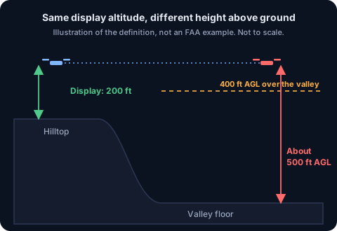 Diagram: a drone at 200 feet on the display over its hilltop launch point is about 500 feet above the valley floor
The reverse also happens. Launch from a valley floor and fly toward rising ground at a steady display altitude, and your height above the slope shrinks. That is a terrain clearance problem, not a legal one, but it is the same mismatch.
The safe habit is to treat the display number as height above your takeoff point and to think about the ground under the aircraft whenever the terrain is not flat.
Does the structure exception cover cliffs and ridges?
The exception in §107.51(b) is written around a structure, its 400-foot radius and its immediate uppermost limit. It does not mention terrain. We would not plan a flight on the assumption that a cliff or a ridge counts as a structure, and an exam question about the exception will be about a structure such as a tower or a building.
Within the exception, the ceiling moves with the structure. Next to a 300-foot tower, staying within 400 feet of it lets you fly up to 700 feet above the ground, since the limit is 400 feet above the tower's top.
Can you get permission to fly higher?
Yes. All of §107.51 is on the list of rules the FAA can waive under §107.205(i). The waivers post covers how that works. Without a waiver, the ceiling is 400 feet above the ground, or the structure limit.
Clouds can lower the ceiling further. On a low-cloud day, the cloud clearance rule in the same section often binds well before 400 feet, which the cloud clearance post works through.
What this means for the exam
Expect the structure exception to show up as a calculation: a tower of a given height, a drone within 400 feet of it, and a question about the maximum altitude. Add 400 feet to the top of the structure. For everything else, read altitudes as height above the ground, and remember that chart heights are a different reference again, which the sectional chart post explains.
The handbook covers all of §107.51 under UA.I.B.K21.
Charts print obstacle tops in MSL and heights in AGL, as the AGL vs MSL post explains.
The free diagnostic scores you against the current exam blueprint, where regulations like §107.51 make up the largest share.
Check your operating-limits knowledgeFree diagnostic
Reading about drones is one thing. Passing the Part 107 test is another. See where you stand.
Take the free 10-minute diagnostic